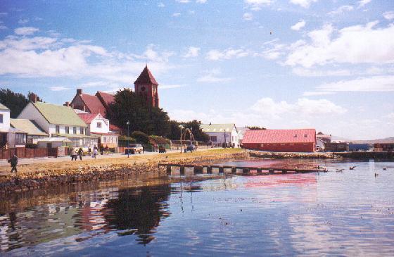
Stanley (also known as "Port Stanley") is the capital and only true city in the Falkland Islands. It is located on the isle of East Falkland, on a north-facing slope, south of Stanley Harbour, in one of the wettest parts of the islands. At the 2006 census, the city had a population of 2,115.
Today, Stanley is the main shopping centre on the islands and the hub of East Falkland's road network. Attractions include the Falkland Islands Museum, Government House, built in 1845 and home to the Governor of the Falkland Islands (currently Nigel Haywood), a golf course, and is known for its whalebone arch, a totem pole, several war memorials and the shipwrecks in its harbour. The Falkland Islands Company owns several shops and a hotel. Stanley has four pubs, eleven hotels & guesthouses, three restaurants, a fish and chips shop and the main tourist office. There are three churches including the Anglican Christ Church Cathedral the southernmost cathedral in the world. The cathedral makes tiny Stanley a city. A grim reminder of the minefields to the south is the bomb disposal unit.
The original capital of the islands was at Port Louis to the north of the present site of Stanley, on Berkeley Sound. Captains Francis Rawdon Moria Crozier and James Clarke Ross were recruited by Governor Moody in his quest to find a new capital for The Falklands. Both Crozier and Ross (who are remembered in Crozier Place and Ross Road in Stanley) were among the Navy's most distinguished seafarers. They spent 5 months in the islands with their ships Terror and Erebus. Governor Moody (after whom Moody Brook is named) however, decided to move the capital to Port Jackson, which was renamed "Stanley Harbour", after a survey. Stanley Harbour was considered to have a deeper anchorage for visiting ships. Not all the inhabitants were happy with the change, notably one JW Whitington is recorded as saying, "Of all the miserable bog holes, I believe that Mr Moody has selected one of the worst for the site of his town."
Work on the settlement began in 1843 and it became the capital in July 1845. It was named after Lord Stanley, Secretary of State for War and the Colonies at the time.
In 1849, thirty married Chelsea Pensioners were settled there to help with the defence of the islands and to develop the new settlement. The settlement soon grew as a deep-water port, specialising at first in ship repairs; indeed, before the construction of the Panama Canal, Port Stanley was a major repair stop for boats travelling through the Straits of Magellan or around Cape Horn. The rough waters and intense storms found at the tip of the continent forced many ships to Stanley Harbour, and the ship repair industry helped to drive the island economy. Later it became a base for whaling and sealing in the South Atlantic and Antarctic.
Wednesday, December 1, 2010

Sunday, November 28, 2010
Beaufort 9 Video
Off of the Falkland Islands in the Weddell Sea of the Southern Ocean, The wind comes out of the Southwest about every three days at an amazing pace, driving before it high seas unlike anything I have ever see, These Gales have very low atmospheric pressures, normally indicitave of a hurricane but have no precipitation or clouds associated. I am sure my weather nerd friends can explain to me why this happens. But I thought it would be fun for you guys to watch.
This was a Beaufort Force Nine and Increasing when I shot these images and the minimum central pressure was 952
Sunday, November 21, 2010
Workboat and FRC (Fast Rescue Craft) Drills off of Uruguay
 |
| Launching the Workboat |
 |
| Workboat Operations |
 |
| Fast Rescue Craft (FRC) |
 The beautiful blue water and clear skies of the South American Coast are gradually giving way to the cloudy and cold southern ocean. The temperature has dropped approximately 10 degrees in the last two days as we progress south. We are all spending as much time on deck as we can as it will become too cold to spend leisure time on deck in the next few days. Our Temperature in the Falklands is expected to be about 12-15 degreesC or about 40 degrees in our numbers.
Saturday, November 20, 2010
The Falkland Islands
 So I'm headed to the Falkland Islands from the Cape Verde Islands on an Atlantic transit as described in the previous posts... Here is a little about the Falklands before I arrive and Detail them myself... There is much more to learn about these islands. Look it up if you wish.
The Falkland Islands (pronounced /ˈfɔːlklənd/; Spanish: Islas Malvinas)[4] are an archipelago in the South Atlantic Ocean, located approximately 250 nautical miles (460 km; 290 mi) from the coast of mainland South America. The archipelago, consisting of East Falkland, West Falkland and 776 lesser islands, is a self-governing British Overseas Territory.[5] The capital, Stanley, is on East Falkland.
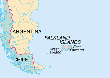
Ever since the re-establishment of British rule in 1833, Argentina has claimed sovereignty.[6] In pursuit of this claim, which is rejected by the islanders,[7] Argentina invaded the Falkland Islands in 1982. This precipitated the two-month-long undeclared Falklands War between Argentina and the United Kingdom and resulted in the defeat and withdrawal of the Argentine forces.
Since the war, there has been strong economic growth in both fisheries and tourism.
The Falkland Islands took their English name from "Falkland Sound", the channel between the two main islands, which was in turn named after Anthony Cary, 5th Viscount Falkland by Captain John Strong, who landed on the islands in 1690.[8] The Spanish name, Islas Malvinas, is derived from the French name,[9] Îles Malouines, named by Louis Antoine de Bougainville in 1764 after the first known settlers, mariners and fishermen from the Breton port of Saint-Malo in France.[9] The ISO designation is Falkland Islands (Malvinas) and its ISO country code is FK.[10]

As a result of the continuing sovereignty dispute, the use of many Spanish names is considered offensive in the Falkland Islands, particularly those associated with the 1982 invasion of the Falkland Islands.[11] General Sir Jeremy Moore would not allow the use of Islas Malvinas in the surrender document, dismissing it as a propaganda term.[12]
The islands were uninhabited when they were first discovered by European explorers, but there is evidence that Patagonian Indians may have reached the Falklands in canoes.[13] Artefacts including arrowheads and the remains of a canoe have been found on the islands.[14] There was also the presence of the Falkland Island fox, or Warrah (now extinct), but warrahs may have reached the islands via a land bridge when the sea level was much lower during the last ice age. A group of islands appeared on maps in the Falkland Island region from the early 16th century, so either Ferdinand Magellan or another early expedition may have sighted them. Amerigo Vespucci may have sighted the islands in 1502, but he did not name them. In 1519 or 1520, Esteban Gómez, a captain in Magellan’s expedition, encountered several islands that members of his crew called "Islas de Sansón y de los Patos" ("Islands of Samson and the Ducks"). These were probably the Jason Islands, northwest of West Falkland, and the names "Islas de Sansón" (or "San Antón," "San Son," and "Ascensión") were used for the Falklands on Spanish maps during this period.[13] Piri Reis, a Turkish admiral of the time who drew reasonably accurate maps, showed islands that may well have been the Falkland Islands.[15]
Early Explorers
There is some dispute about which European explorer first set foot on the islands. The islands appear on numerous Spanish and other maps beginning in the 1520s.[14] The English explorer John Davis, commander of the Desire, one of the ships belonging to Thomas Cavendish's second expedition to the New World, is recorded as having visited the islands in 1592.[16] He was separated from Cavendish off the coast of what is now southern Argentina by a severe storm and discovered the islands. For a time the islands were known as "Davis Land".[13] In 1594, the English commander Richard Hawkins visited the islands. Combining his own name with that of Queen Elizabeth I, the "Virgin Queen", he gave them the name of "Hawkins' Maidenland." Many give the credit to Sebald de Weert, a Dutchman, who discovered the islands in 1600.[14]
In January 1690, Captain John Strong of the Welfare was heading for Puerto Deseado (now in Argentina). Driven off course by contrary winds, he reached the Sebald Islands instead and landed at Bold Cove. He sailed between the two principal islands and called the passage "Falkland Channel" (now Falkland Sound), after Anthony Cary, 5th Viscount Falkland, who as Commissioner of the Admiralty had financed the expedition (Cary later became First Lord of the Admiralty). The island group later took its English name from this body of water.
References
1. Joshua Project. "Ethnic People Groups of Falkland Islands". Joshua Project. http://www.joshuaproject.net/countries.php?rog3=FK. Retrieved 28 February 2010.
2. Falkland Islands Government (30 August 2007). "Falkland Islands Government appoints new Chief Executive". Press release. http://www.falklands.gov.fk/news-2007.php. Retrieved 29 October 2007.
3. a b "Falkland Islands (Islas Malvinas)". CIA. https://www.cia.gov/library/publications/the-world-factbook/geos/fk.html. Retrieved 5 March 2010.
4. "WordReference, English-Spanish Dictionary. ''Falklands: the Falklands, las (islas) Malvinas''". Wordreference.com. http://www.wordreference.com/es/translation.asp?tranword=Falklands&B10=Buscar&dict=enes. Retrieved 15 March 2010.
5. "Welcome to the Falkland Islands Government Legislative Assembly Website". The Falkland Islands Government. http://www.falklands.gov.fk/assembly/. Retrieved 13 June 2010.
6. "Islas Malvinas, Georgias del Sur y Sandwich del Sur". Secretaría de Relaciones Exteriores [Argentine Ministry of Foreign Affairs]. http://www.cancilleria.gov.ar/portal/seree/malvinas/home.html. Retrieved 6 March 2010.
7. "Country Profile: Falkland Islands, Sovereignty of the Islands". Countries & Regions. Foreign and Commonwealth Office. 27 July 2007. http://www.fco.gov.uk/en/about-the-fco/country-profiles/south-america/falkland-islands?profile=history&pg=3. Retrieved 4 April 2008.
8. Peter J. Pepper. "Port Desire and the Discovery of the Falklands". Falkland Islands Newsletter, No. 78, March 2001. http://www.falklands.info/history/histarticle19.html. Retrieved 6 March 2010.
9. a b "Falkland Islands Guide". Blog at Worldpress.com. http://falklandislandsguide.wordpress.com/. Retrieved 6 March 2010.
10. "English country names and code elements". International Organization for Standardization. http://www.iso.org/iso/english_country_names_and_code_elements#f.. Retrieved 6 March 2010.
11. "AGREEMENT OF 14th JULY 1999". Falklands.info. http://www.falklands.info/background/99agree.html. Retrieved 23 July 2007.
12. "PSYOP of the Falkland Islands War". psywar.org. http://www.psywar.org/falklands.php. Retrieved 23 July 2007.
13. a b c "History : Falkland Islands : Locations : Welcome to the Learning Zone : Visit & Learn". Royalnavy.mod.uk. http://www.royalnavy.mod.uk/visitandlearn/learning-zone/locations/falkland-islands/history/. Retrieved 15 March 2010.
14. a b c "Falkland Islands". Britishislesgenweb.org. 20 January 2009. http://www.britishislesgenweb.org/index.php/falkland-islands. Retrieved 15 March 2010.
15. "Piri Reis and the Hapgood Hypotheses". Saudi Aramco World. Saudi Aramco World. 1980. http://www.saudiaramcoworld.com/issue/198001/piri.reis.and.the.hapgood.hypotheses.htm. Retrieved 10 April 2010. Piri Reis' information appears to have been partly based on an original chart drawn or used by Christopher Columbus and captured by the Turks from the Spanish.
Sunday, November 14, 2010
Line Crossing (Shellback) Ceremony Tradition
"It has been a long maritime tradition to initiate "pollywogs" into the Kingdom of Neptune - the legendary god of the seas, upon their first crossing of the Equator. Captains of ships have always taken time, either in war or peace, to uphold this long practiced ceremony. The ceremony has changed in recent years due to gender factors, but the intent is still very much alive. It should also be noted that the tradition holds no regard for rank. Officers and Deck Crew are treated equally (or nearly so, as you will see below).
A ship knowing it will cross the Equator will pile up stores of garbage and smelly clothes and anything that is vile but not life threatening. On the appointed day and time the uninitiated are led out on deck, usually in humiliating garb (bathing suits underneath - nowadays!), paraded around the deck, and made to do unspeakable things. Actually it is great fun and no one is supposed to get hurt (although the occasional accident occurs). The 'wogs' have their heads shaved, and then are made to run a gauntlet, being belted with greased socks stuffed with rags or other such instruments, crawl through the garbage, suffer other indignities, and at the end you HAVE to kiss the belly of Neputne. This is usually the fatest, biggest beer gut guy they have on board. He'll grab you by the ears and rub your face in his belly which is covered with mustard, oil and stuff. When he feels you have suffered enough you are pronounced a "Shellback".
Afterwards, a good hot shower is had and usually a good hot meal. You are issued an official 'Shellback' card. You must keep this card, because if you lose it you will have to go through the ordeal again. There are no exceptions to this rule. I knew many sailors who did lose their cards. I even knew a guy who thought he lost his card, went through all that stuff again and then found his original card later. "
~ Special Thanks to the US NAVY LST 174 for this Description

A ship knowing it will cross the Equator will pile up stores of garbage and smelly clothes and anything that is vile but not life threatening. On the appointed day and time the uninitiated are led out on deck, usually in humiliating garb (bathing suits underneath - nowadays!), paraded around the deck, and made to do unspeakable things. Actually it is great fun and no one is supposed to get hurt (although the occasional accident occurs). The 'wogs' have their heads shaved, and then are made to run a gauntlet, being belted with greased socks stuffed with rags or other such instruments, crawl through the garbage, suffer other indignities, and at the end you HAVE to kiss the belly of Neputne. This is usually the fatest, biggest beer gut guy they have on board. He'll grab you by the ears and rub your face in his belly which is covered with mustard, oil and stuff. When he feels you have suffered enough you are pronounced a "Shellback".
Afterwards, a good hot shower is had and usually a good hot meal. You are issued an official 'Shellback' card. You must keep this card, because if you lose it you will have to go through the ordeal again. There are no exceptions to this rule. I knew many sailors who did lose their cards. I even knew a guy who thought he lost his card, went through all that stuff again and then found his original card later. "
~ Special Thanks to the US NAVY LST 174 for this Description

Ocean Transit


We are transiting from Cape Verde (Senegal) West Africa to the Falkland Islands at roughly 45 degrees South Lattitude. A lot of folks would pay for such a trip... Instead they are paying me... We have been at sea for 4 days now... At 4pm we crossed the equator into the southern hemisphere... Something I had forgotton about was that equatorial crossings, for those who dont have proof of prior transit or in my case have never actually gone beyond the line, entails a horrifying Line Crossing Ceremony. I have now been fully baptised in god knows what, by the Imperium Neptuni Regis (King Neptunes Court). Yes basically I was dunked in a bathtub full of kitchen scraps and ichky stuff and made to drink some concoction of hot sauce and oooky juice... It was gnarly... We are now officially sailing upside down on the world. Afterward we were treated to an awesome BBQ on the quarterdeck but will will probably never get the smell out of our clothes from the goop they dunked us in

Wednesday, October 27, 2010
Cape Verde

 So... Here we go... VISA applied for Cape Verde Islands off of West Africa for a transocean transition to the Falkland Islands... This should be awesome... crossing the equator and going to the end of the world!!! WooHoo!!! No need for bulletproof vests this trip, cause I don't think the Penguins are packing heat. We were going to crew change out of Chili but the Argentine Government said we would be crossing into their waters and since we will be working off of the Falklands (Think 1982, Margaret Thatcher and Great Britain) they would seize our vessel and arrest the crew. SO first change is as the boat heads south from the North Sea and the rest will be on god knows what into Port Stanley, Falklands.
The Cape Verde chain lies in the North Atlantic Ocean, some 800 km (500 mi) from the coast of Senegal, Africa.
Cape Verde is also the birthplace of many of the significant hurricanes to travel across the Atlantic each year and make landfall in North America.

A Cape Verde-type hurricane is an Atlantic hurricane that develops near the Cape Verde islands, off the west coast of Africa. The average hurricane season has about two Cape Verde-type hurricanes, which are usually the largest and most intense storms of the season because they often have plenty of warm open ocean over which to develop before encountering land. The five largest Atlantic tropical cyclones on record have been Cape Verde-type hurricanes. Some of the longest-lived tropical cyclones in the Atlantic basin are Cape Verde hurricanes. While many move harmlessly out to sea, some move across the Caribbean sea and Gulf of Mexico, becoming damaging storms for Caribbean nations, Mexico, Bermuda, the United States, and occasionally even Canada. Research projects since the 1970s have been launched to understand the formation of these storms.
References
1. Chris Landsea (1997-07-18). "FAQ: HURRICANES, TYPHOONS AND TROPICAL CYCLONES (Part 1 of 2) Subject: A2) What are "Cape Verde"-type hurricanes?". Faqs.org. http://www.faqs.org/faqs/meteorology/storms-faq/part1/. Retrieved 2009-10-08.
2. National Hurricane Center (2009). "Atlantic hurricane database". National Oceanic and Atmospheric Administration. http://www.nhc.noaa.gov/tracks1851to2009_atl_reanal.txt. Retrieved 2009-10-08.
3. Colin J. McAdie, Christopher W. Landsea, Charles J. Neumann1, Joan E. David, Eric S. Blake, and Gregory R. Hammer (2009). Historical Climatology Series 6-2: Tropical Cyclones of the North Atlantic Ocean, 1851–2006 (with 2007 and 2008 track maps included). National Climatic Data Center. p. 161. http://www.nhc.noaa.gov/pdf/TC_Book_Atl_1851-2006_lowres.pdf. Retrieved 2009-10-08.
4. National Oceanic and Atmospheric Administration (2007-02-01). "Feature Stories : Fifty Years of NOAA Hurricane Research". Department of Commerce. http://celebrating200years.noaa.gov/magazine/50yrs_hurricane_res/image4.html. Retrieved 2010-01-20.
5. R. K. Kakar (Fall 2006). "NASA's Three Pronged Approach to Hurricane Research". National Oceanic and Atmospheric Administration. http://adsabs.harvard.edu/abs/2006AGUFM.A21H..01K. Retrieved 2010-01-20.
6. Jon Hamilton (2006-10-17). "Off Africa's Coast, a Hurricane Nursery". National Public Radio. http://www.npr.org/templates/story/story.php?storyId=6263948. Retrieved 2010-01-20.


Subscribe to:
Posts (Atom)